
Slash Fertilizer Costs Up To 30% & Crush Pests with Drone Mapping!
Get actionable insights to spot issues 5-7 days sooner, optimize your resources, and boost yields. Lock in pre-season rates now-limited spots available!
Why Choose Overwatch Land Mapping for Your Farm?
Proven results that help you optimize inputs, prevent losses, and maximize yields
Spot Issues Early
Detect nutrient gaps and pests 5-7 days sooner than the human eye-prevent losses before they start.
Optimize Efficiency
Cut labor, fertilizer, and pesticide costs while maximizing yields. Farmers report up to 30% savings on inputs.
Secure More Funding
Win more EQIP grants with more precise, objective data. Scalable solutions fit any operation size.
Unmatched Precision
Unlike satellite imagery, our drones capture ultra-high-res, multispectral images down to 2 cm/px for pinpoint analysis.
Potato Growth - A Real World Example
Value at every critical stage with precision drone land mapping
| Growth Stage | Estimated Window | What We Identify | The Bottom Line (ROI) |
|---|---|---|---|
1 Emergence & Vegetative | 20 – 45 DAP |
| Don't guess the stand: Re-plant decisions or insurance claims based on hard data, not a walk-through. |
2 Tuber Initiation | 45 – 70 DAP |
| Maximize Tuber Set: Get the nitrogen where it's needed to trigger maximum tuber formation before bulking begins while optimizing input costs. |
3 Canopy Closure | 60 – 85 DAP |
| Save the Field: One prevented Blight outbreak in a closed canopy can save $20,000+ in a single 100-acre circle. |
4 Tuber Bulking | 70 – 110 DAP |
| Keep 'em Green: Every extra day the canopy stays healthy during bulking adds weight and "size-up" to your tubers. |
5 Maturation & Senescence | 110 – 140+ DAP |
| Precision Vine-Kill: Time your desiccant application to ensure perfect skin-set and specific gravity for storage. |
How Overwatch Land Mapping Works
A simple 4-step process to transform your farm operations
Schedule & Fly
Book a drone mapping session. Our experts fly our drone over your fields to capture high-res multispectral image data.
Analyze & Insight
We process the data with AI to identify nutrient gaps, pests, and optimization opportunities.
Implement & Save
Receive a custom report with actionable recommendations. Use the data to decide on precise, efficient action to slash costs and boost output.
Strategic Growth
We turn seasonal data into a long-term digital asset, supporting yield forecasting, insurance documentation, and grant applications.
What You'll Get from our Multispectral Drone Land Mapping Service
Customized Report with Actionable Recommendations
We'll provide a detailed, easy-to-understand report highlighting key findings from your fields, such as early detection of crop stress, nutrient deficiencies, water issues, pests, or diseases, as detected by our best in class aerial drone sensors.
This is a tool that you can use to decide on precise follow-up actions, for example: detailed scouting, developing an optimized fertilizer plan with your agronomist, or changing irrigation rates.
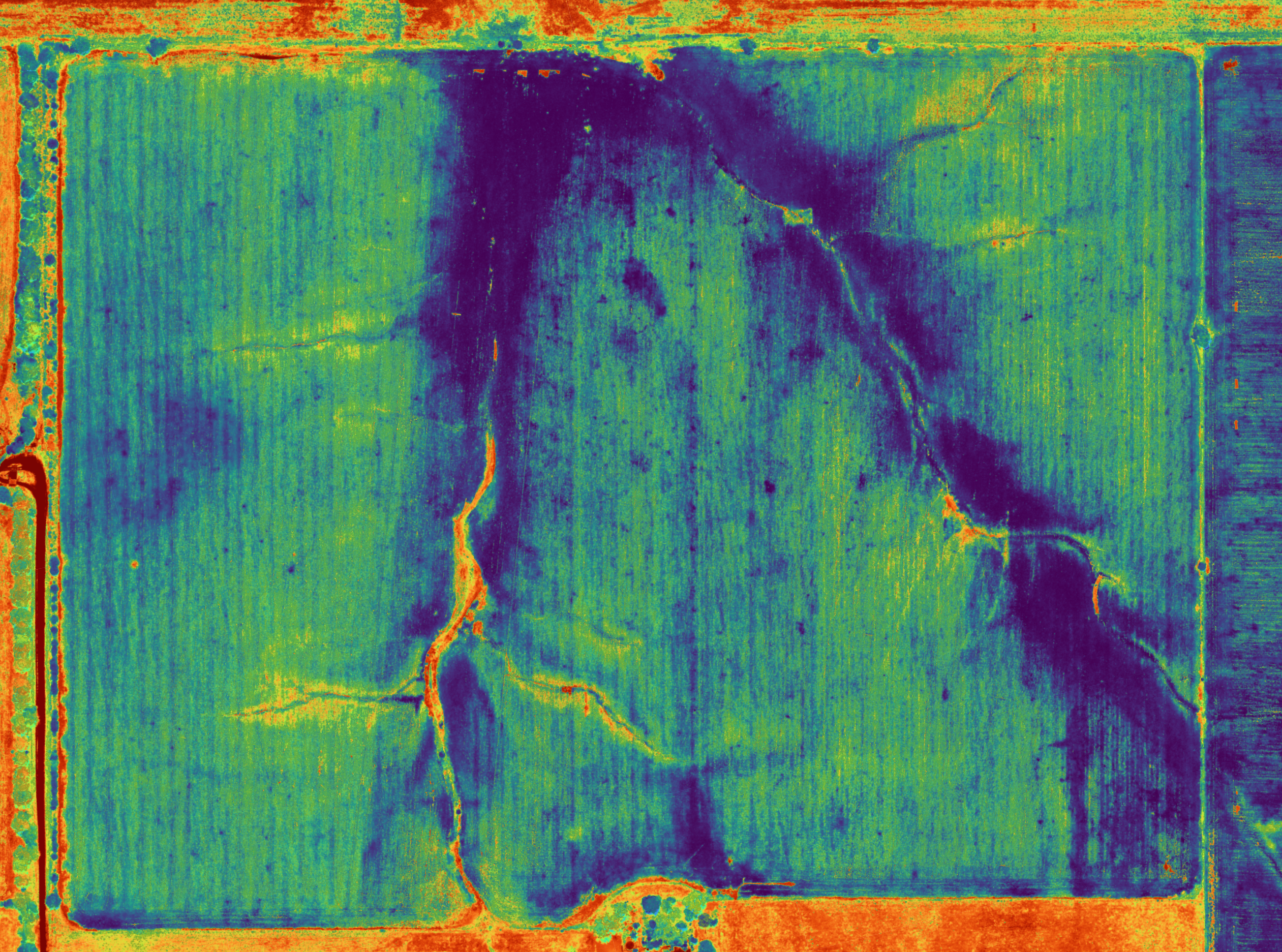
High-Resolution, Interactive Layered Maps
Access stunning orthomosaic imagery and multispectral layers (e.g., NDVI for overall plant health, NDRE for nitrogen status, VARI for vegetation density) at resolutions down to 2 cm/pixel.
Through our secure sharing portal, you can view, zoom, annotate, and collaborate on these live maps from any device-mark problem areas, add notes, or share with your agronomist or team for real-time decision-making
Flexible Data Exports for Seamless Integration
We'll provide a zonal management map file derived from multispectral indices (e.g., NDVI/NDRE-based zones for variable-rate applications) in industry standard formats like shapefiles, GeoTIFF, GeoJSON, KML or equipment-specific files (e.g., for John Deere Operations Center, Climate FieldView, or Trimble).
These allow you or your agronomist to easily import into farm management software to create customized prescriptions for variable-rate applications - putting the informed decision-making in your hands and ensuring our insights translate straight to on-field action.
Your Trusted Partner in Farm Innovation
Overwatch Land Mapping is a Manhattan, Montana based leader in drone based agricultural land mapping, specializing in advanced multispectral imagery.
Our mission: Empower farmers to thrive with precise, data driven insights.
100% Satisfaction Guarantee
We stand behind our work with a complete satisfaction guarantee
Secure Data Handling
We use NDAA compliant platforms to ensure your farm data is protected
Certified & Insured Pilots
All our pilots are fully FAA-certified and insured for your peace of mind
Don't Miss Pre-Season Rates-Lock In Savings Now!
Use the calendar below to book your free phone consultation and custom quote.
Or email us at:
overwatchgeo@proton.meWe respect your privacy-your info is secure and never shared.