
Grant programs like USDA NRCS EQIP, CSP, and state-level conservation incentives are more competitive than ever. Reviewers prioritize proposals that demonstrate innovation, measurable environmental benefits, and data-driven outcomes - such as reduced inputs, improved soil health, and lower runoff.
Multispectral drone mapping services from providers like Overwatch Land Mapping gives your application a clear advantage by delivering high-resolution, timely, and scientifically robust data that generic precision ag approaches can't match.
What Grant Reviewers Really Want
Successful precision ag grant proposals stand out when they:
- Show quantifiable impact (e.g., "15-30% reduction in nitrogen use").
- Use advanced technology for monitoring and verification.
- Provide baseline data and ongoing proof of practice adoption.
- Align with priorities like water quality, carbon sequestration, and resource efficiency.
Multispectral drone imagery checks every box - with details that satellite or RGB-only methods simply can't provide.
How Multispectral Drone Mapping Elevates Your Proposal
At Overwatch Land Mapping, we capture cm-level resolution imagery across multiple spectral bands (visible + near-infrared/red edge). This enables precise calculation of indices like:
- NDVI/NDRE → Early nutrient stress detection.
- Chlorophyll content → Targeted variable-rate nitrogen prescriptions.
- Water stress indices → Optimized irrigation zoning.
These translate directly into grant-winning metrics:
- Reduced fertilizer/herbicide use (up to 30%) via spot-application maps.
- Documented yield protection through early issue detection.
- Environmental wins like less runoff and better soil health - backed by hard data.
You can include sample maps, projected savings, and third-party validated outcomes in your application.
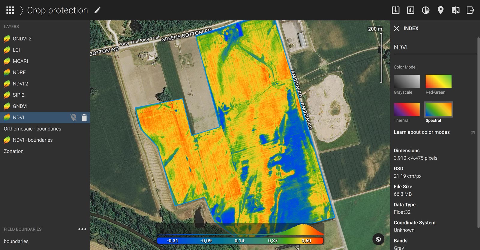
High-resolution drone-derived NDVI map revealing zone-level variability - perfect for grant reporting.
Comparison: Multispectral Drones vs. Satellite or RGB Imagery
| Feature | Satellite Imagery | RGB Drone Imagery | Multispectral Drone Mapping (Overwatch Land Mapping) |
|---|---|---|---|
| Resolution | 10–30 meters | cm-level (visual only) | cm-level + multi-band spectral |
| Timing/Frequency | Fixed schedule, cloud-dependent | On-demand | On-demand, clear-day flexibility |
| Data Depth | Basic NDVI, delayed | High-res photos/videos | Advanced indices (NDRE, chlorophyll, stress) |
| Early Detection | Limited (coarse + late) | Visible issues only | 5–7 days earlier via spectral signatures |
| Grant Metrics | Broad estimates | Qualitative scouting | Precise, quantifiable reductions & outcomes |
| Cost Effectiveness | Low/free but low value | Moderate | Higher ROI through targeted savings |
| Proposal Strength | Basic compliance | Better | Stands out - shows cutting-edge commitment |
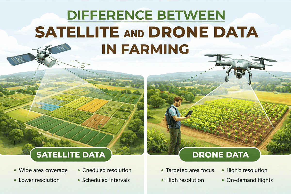
Satellite data covers wide areas but lacks detail; drones deliver targeted, actionable insights.
Real-World Grant Advantage
Farmers using multispectral drone data have secured funding by attaching:
- Before/after prescription maps showing input reductions.
- Zone-specific reports tied to conservation practices.
- Integration proof (e.g., John Deere Ops Center or Climate FieldView exports).
This level of specificity signals to reviewers that you're serious about results - not just checking boxes.
Ready to Strengthen Your Next Grant Application?
Don't settle for generic precision ag claims. Multispectral drone mapping from Overwatch Land Mapping provides the detailed, defensible data that turns good proposals into funded ones.
Contact us for a free consultation - we'll help you showcase drone-powered practices that get noticed.
Overwatch Land Mapping – Local Precision Ag Drone Services in the Gallatin Valley, Montana